2012-06-17 16h03m19la souche

Michel07
Utilisateur
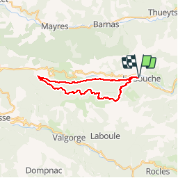

Longueur
22 km

Altitude max
1244 m

Dénivelé positif
957 m
Km-Effort
35 km

Altitude min
526 m

Dénivelé négatif
955 m
Boucle
Oui
Date de création :
2014-12-10 00:00:00.0
Dernière modification :
2014-12-10 00:00:00.0
5h17
Difficulté : Difficile

Application GPS de randonnée GRATUITE
 SityTrail
IGN / Instituts géographiques
SityTrail Plus
Le monde est à vous
À propos
Randonnée Marche de 22 km à découvrir à Auvergne-Rhône-Alpes, Ardèche, La Souche. Cette randonnée est proposée par Michel07.
Localisation
Pays :
France
Région :
Auvergne-Rhône-Alpes
Département/Province :
Ardèche
Commune :
La Souche
Localité :
Unknown
Départ:(Dec)
Départ:(UTM)
595032 ; 4942504 (31T) N.
Commentaires